Nauru 99 Mirai Lidar Summary
Please see the paper in "Sea and Sky" as well [pdf file (768 k)].
Aerosol Distribution and Relationship with Meteorological Parameters
Figures 1 and 2 show temporal variation of vertical profile of aerosols and cloud distribution measured with the lidar on R/V Mirai during IOPs phase 2 and phase 3ÅiJune 20-30 and July 1-4 or Julian day 171-181 and 182-185). Figure 3 shows profiles of relative humidity observed with radio sondes from R/V Mirai.
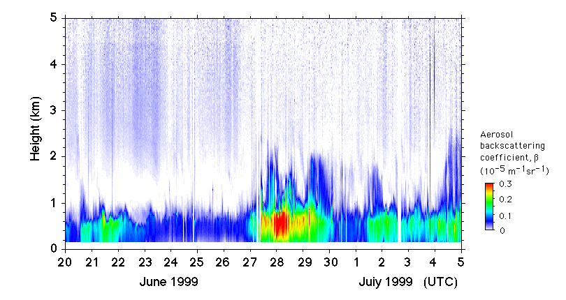
Fig. 1 Temporal variation of aerosol backscatter coefficient at 532 nm observed with the lidar.
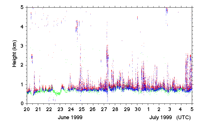
Fig. 2 Cloud base height, apparent cloud top height, and aerosol layer upper boundary height measured with the lidar.
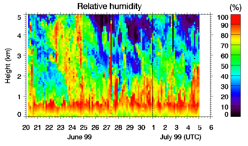
Fig. 3 Relative humidity observed with radio sondes. (Other sonde data are here .)
It can be seen from Figs 1 and 3 that the structure of aerosol distribution is closely related to the structure of relative humidity. The structures of aerosol distributions in the atmospheric boundary layer up to 600 m to 1000 m height and aerosol layers above the boundary layer sometimes observed up to about 2 km height coincide with high humidity regions (e.g. June 27, 28, 29, and July 1 and 4 (or Julian day 178, 179, 180, 183 and 185)). During the first half of phase 2, a high humidity layer is observed up to about 5 km altitude. The corresponding aerosol layer is also seen with the lidar, though it is optically very thin. Though there is a similarity in distribution patterns of aerosols and relative humidity, there is no simple relationship between the value of backscatter coefficient and relative humidity. As discussed later, aerosol concentration (backscatter coefficient) has a strong correlation with surface wind speed.
Figure 4 shows integrated backscatter coefficient (IBC), the ratio of backscatter coefficient at 1064 nm and 532 nm, and cloud fraction obtained from the lidar data. IBC is the quantity that can be converted to optical depth by multiplying by the lidar ratio (extinction-to-bacscattering ratio). The ratio of backscatter coefficient at the two wavelengths indicates particle size of aerosols. Particle size is larger when the value is larger (close to 1). The cloud fraction is defined as the ratio of lidar profiles detecting clouds in a height range of 0 to 3 km. Figure 5 shows meteorological parameters observed on Mirai.
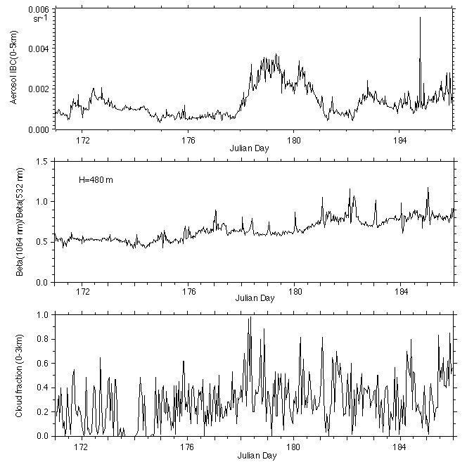
Fig. 4 Integrated backscatter coefficient, ratio of backscatter coefficient at 1064 nm and 532 nm, and cloud fraction obtained from the lidar.
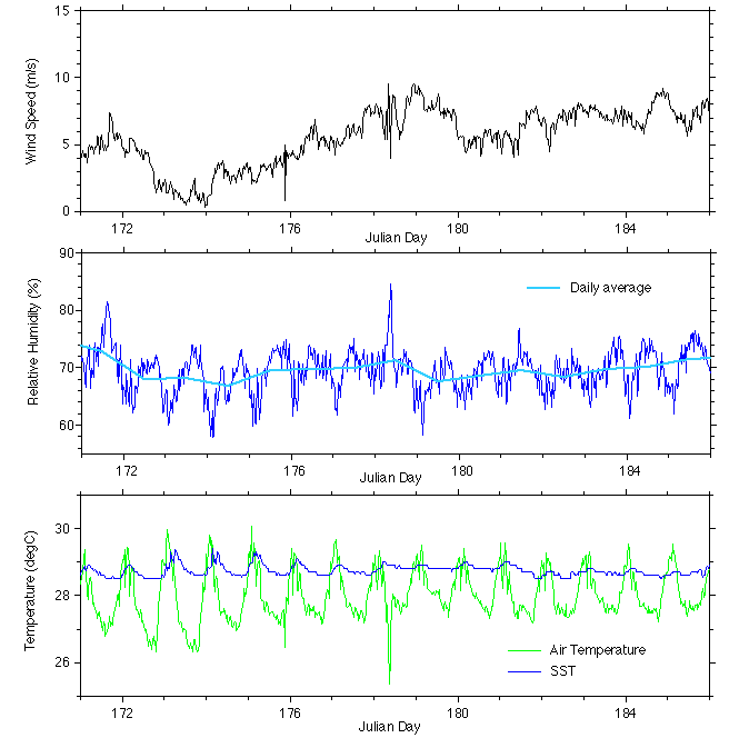
Fig. 5 Surface wind speed, relative humidity, atmospheric temperature, and sea surface temperature observed on Mirai.
We can see from these data that there is a strong correlation between aerosol concentration (IBC) and surface wind speed. It indicates that surface wind plays essential role in the generation of aerosols. The result is consistent with the deposition measurement on Mirai which shows the aerosols were mostly sea salt. Sea salt aerosols are generated by breaking of surface waves. However the relationship between IBC and wind speed is complicated (i.e. IBC-wind speed plot scatters) probably because of the difference of the locations where aerosols were generated and observed.
The ratio of backscatter at the two wavelength is larger (i.e. particle size is larger) where wind speed is high. Relative humidity also shows a correlation between wind speed. Consequently, there can be two effects concerning aerosol particle size. One is the effect of wind speed on generated particle size, and the other is the effect of relative humidity on existing particles.
Cloud coverage was high in the windy periods. Also the cloud base height (or the boundary layer height) was also slightly higher in the periods as seen Fig. 2. We may summarize as follows. When wind spped was high, aerosol concentration was higher, particle size was larger, relative humidity was slightly higher, boundary layer hight was slightly higher, and cloud fraction was higher.
It is difficult to discuss the correlation between aerosols and cumulus clouds. However, we can see that aerosol layers above the boundary layer are observed only when aerosol concentration in the boundary layer is high. On June 30 (Julian day 181) the cumulus activity was high, but aerosol concentration above the boundary layer was low. In this example, aerosol concentration in the boundary layer was low. This indicates that aerosols in the upper layer are transported from the boundary layer probably with the cumulus activity. The mechanism of the transportation and the effect of aerosols on the cumulus characteristics are interesting subjects of the future study.
Comparison with Sunphotometer Measurements
Figure 6 shows comparison of aerosol optical thickness obtained with lidar and the sunphotometer. A lidar ratio of 25 (sr) was assumed to obtain optical thickness from lidar IBC. The minimum optical thickness with the sunphotometer agrees with that with the lidar. The large optical thickness values sometimes obtained with the sunphotometer are probably due to the effect of clouds.
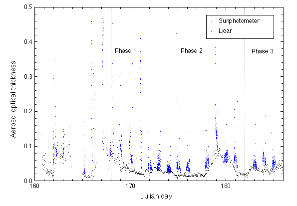
Fig. 6 Temporal variation of aerosol optical thickness observed with the lidar and the sunphotometer.
A diurnal change in aerosol optical thickness is seen in the sunphotometer data. The diurnal change is not seen in the lidar data. (It can be an error in the sunphotometer data analysis, which may be related to the solar elevation angle.)
(Figure: Diurnal variation of AOT with the sunphotometer)
Aerosol optical thickness was higher in the second half of IOP Phase 2 where surface wind speed was high, as discussed in the previous section. Aerosol optical thickness was sometimes high also in IOP phase 1. In this period, the ship was near the Nauru island. However, ion constituents obtained from the deposition measurement show aerosols were mostly sea salt.
Figure 7 shows temporal variation of Angstrom exponent obtained with the lidar and the sunphotometer.
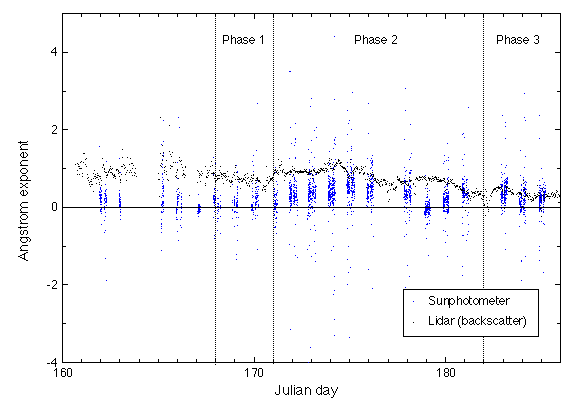
Fig. 7 Temporal variation of lidar backscatter Angstrom exponent (h=480 m) and sunphotometer Angstrom exponent.
Angstrom exponent from the sunphotometer is close to zero when optical thickness is large. Backscatter Angstrom exponent (exponent of wavelength dependence of backscatter coefficient) obtained from the two-wavelength lidar shows a complicated behavior. We can see from Fig. 7 and the variation of relative humidity in Fig. 8 that the lidar backscatter Angstrom exponent may have a negative correlation with daily averaged relative humidity. The sunphotometer Angstrom exponent does not show such a clear humidity dependence. The difference can be explained by the different humidity dependence of backscatter and extinction.
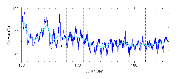
Fig. 8 Temporal variation of relative humidity measured on Mirai.
Figures 9 and 10 show dependence of Angstrom exponent on optical thickness for the sunphotometer and the lidar. Phase 1, 2 and 3 are indicated with different colors. In the lidar plot, the data from the whole period of MR99-K03 cruise are indicated. Aerosols in the latitude region higher than 25 deg north (the red dots in Fig. 10), where the influence of Asian continent is large, show different characteristics.
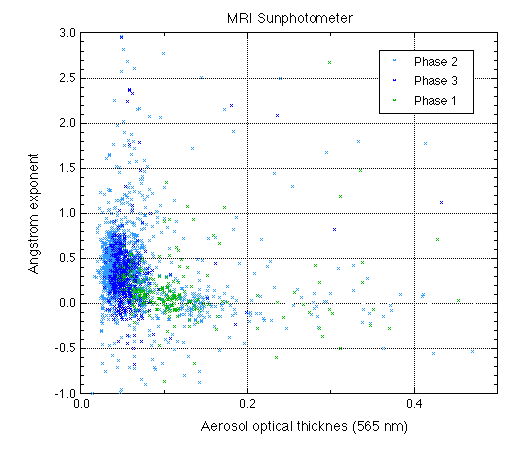
Fig. 9 Dependence of Angstrom exponent on optical thickness obtained from the sunphotometer.
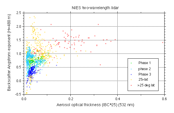
Fig. 10 Dependence of backscatter Angstrom exponent on optical thickness obtained from the two-wavelength lidar.
Links
Mirai Meteorological data
Radiosonde data
Sunphotometer data
Chemical deposition data
Lidar data